England-2011-lab2-yellow
Lab 2: Holy Pigeon P$#! Batman, it's Penelope Poison!
We are still working on editing this wiki page (Im progress :))
Problem Description and Approach
Our task as the Yellow Team was to collect data from various water bodies in order to gauge the possible effects of releasing a toxic substance into London’s water supply. Dr. Obfuscation only provided photographs of the 11 locations where Penelope Poison threatened to release these toxic substances. We needed to figure out the geographical coordinates (latitude and longitude) of these locations, measure the air and water temperature, our elevation and note the wind speed plus direction at the times we were at these locations. Most importantly, we needed to figure out what the most accurate approach to collecting this data was, and what if any flaws there were in collecting this data. Time was also a factor to keep in mind, so we decided to tackle the location not in alphabetical order, but in the order of their proximity to one another.
Data Collection
Latitude, Longitude and Elevation using an eTrex GPS navigator
In order to determine the latitude, longitude and the elevation we used a GPS navigator powered by AA batteries. After turning the device on, three minutes were allowed to pass before readings were taken from the device for the first time in order to give it enough time to recognize enough satellites in order to provide accurate readings. For the second reading, the GPS device was turned off and on again, with a two minute interval before announcing the readings on the screen. For the third reading, the same procedure was followed except an interval of one minute was allowed before recording the readings produced by the device.
Wind direction using a compass and Tesco plastic bag
We laid the compass on a flat surface ( someone's palm, on the ground, on the surface of a flat bench) to help us determine the direction (north, west, east and south) of the location of the water body,. Three of the group members would each stand parallel to the compass with the plastic bag on their hand and observe the direction of the wind.
Wind speed using the Beaufort Scale
Wind speed was collected using the Beaufort Scale, a standardized method using visual estimations of the effect of the wind on objects such as a Tesco plastic bag, body of water and tees. When using the plastic bag, it was important to make sure that it was completely unfolded and had no residue of any sort inside it. It was held on at an arms length for 30 seconds. The extent of movement by the plastic bag was then visualized against the description of the Beaufort and awarded a number that matched the images of water used on the wikipedia page to distinguish between different wind speeds. When observing the water, it was important to make sure that the observer watcher its surface for at least one minute in order to establish a steady rate of motion on the surface of the water as a result of the wind. Lastly, when observing the trees, it was important to watch one specific tree for one minute in order to establish the effect of the speed of the wind on the leaves. This was done at every location.
Air and Water Temperature using the Maplin thermocouple thermometer
In order to measure the temperature for the air and water we used the Maplin thermocoupla thermometer device provided to us by Charlie Peck. This device consists of a screen for taking readings, an on and off button, a hold button, and a small metal rod attached to a wire on the back of the device for taking temperature measurements. At each location we went to we took out the rod, turned on the device, left it on for two minutes and then took the reading, copied the temperature reading onto our data sheet, then turned off the device for one minute and repeated this process twice more copying the respective readings onto our notes. Then using the same tool we put the small rod into the water at each location, here it was important to make sure the rod was immersed significantly in the water, we left the rod for two minutes, removed it from the water and copied the temperature from the screen. We then dried off the rod waited one minute and repeated this process twice.
Finding places
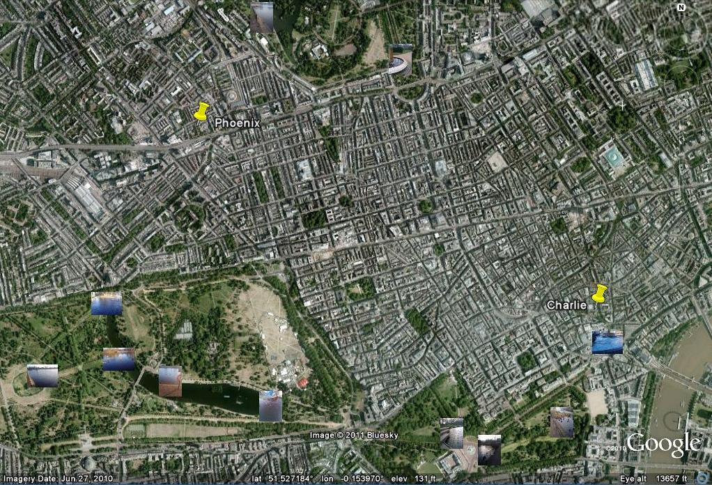
Nowadays there is more data stored in a single photo than can be seen in the photo itself. Information including when the photo was taken and with what equipment the photo was taken is available in data stored within pictures. Some cameras even have GPS devices incorporated into their mechanics allowing them to store the coordinates of the location at which the photo was taken (geocoding). The pictures provided by Dr. Obfuscation contained information which contained coordinates which could be read and further integrated into satellite images on Google Earth using Picasa.
The picture below demonstrate the integration of the photos provided by Dr. Obfuscation and Google Earth, which enabled us to tactfully choose which locations to record date from first.

Error Analysis
Latitude, Longitude and Elevation
We checked on the Garmin website, the Etrex Vista C, is accurate within 30 meters and 95% of the time. Its accuracy and errors also largely depends on how many satellites it can find.
Wind Direction using a compass and Tesco plastic bag
It was hard having the compass on a flat surface in some areas as most readings were taken while it was on someone's palm ( a surface that is not even). In addition, regular compasses are not made to point exact North, but relative North which a point with a particularly strong magnetic pull. Therefore many of the objects we identified as being North or South of the water bodies might not have been so, if we were looking for a precise bearings. When experiencing light winds, a Tesco plastic bag might prove to be denser than the wind thus making it impossible to show which direction the wind is moving. Using objects that have a similar density to air, such as dyed smoke or cigarette smoke might be more efficient in showing much lighter winds.
Wind Speed using the Beaufort Scale
The primary error with using the Beaufort scale to measure wind speed is that every humans capacity to estimate the similarity of the effect of wind on an object that is not water (as was originally the case) is that everyone perception is different. When using the plastic bag,a source of era was its density. At times, when the force of wind speed was lesser than the density of the plastic bag, it failed to move this leading to the observatoon that there was no wind when in actual fact there might have been some movement at extremely low speeds. Secondly, when using the water as a means to estimate the wine speed, our method did not account for movement caused by other objects such as animals in the water body or man made objects such as paddle boats. This may have indicated that the wind speed was greater than was the actual case. Lastly with using the trees, a primary source of error was due to the season where most of the leaves haveel fallen out. Similar to the plastic bag, some winds might be too slow to cause movements among the branches of the tree- once again resulting in estimating wind speeds that might be slower than is the actual case.
Air and Water Temperature using the Maplin thermocouple thermometer
Sources of error that we experienced in collecting air and water temperature were both mechanical and human errors. Although we dried the rod after each reading the rod may still have been chilled which may have affected the results of the next air temperature reading. As far as documenting water temperatures we experienced problems with accuracy due to an inability in some locations to immerse the rod without it being in contact with stone. Also the varying depth of the bodies of water may have had some effect on the accuracy of the readings. In the manual of this device it is written that its error is +- 3%.
Images
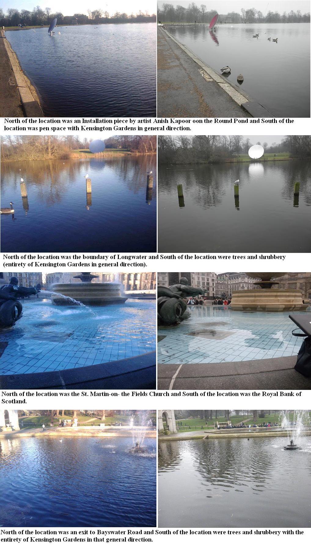
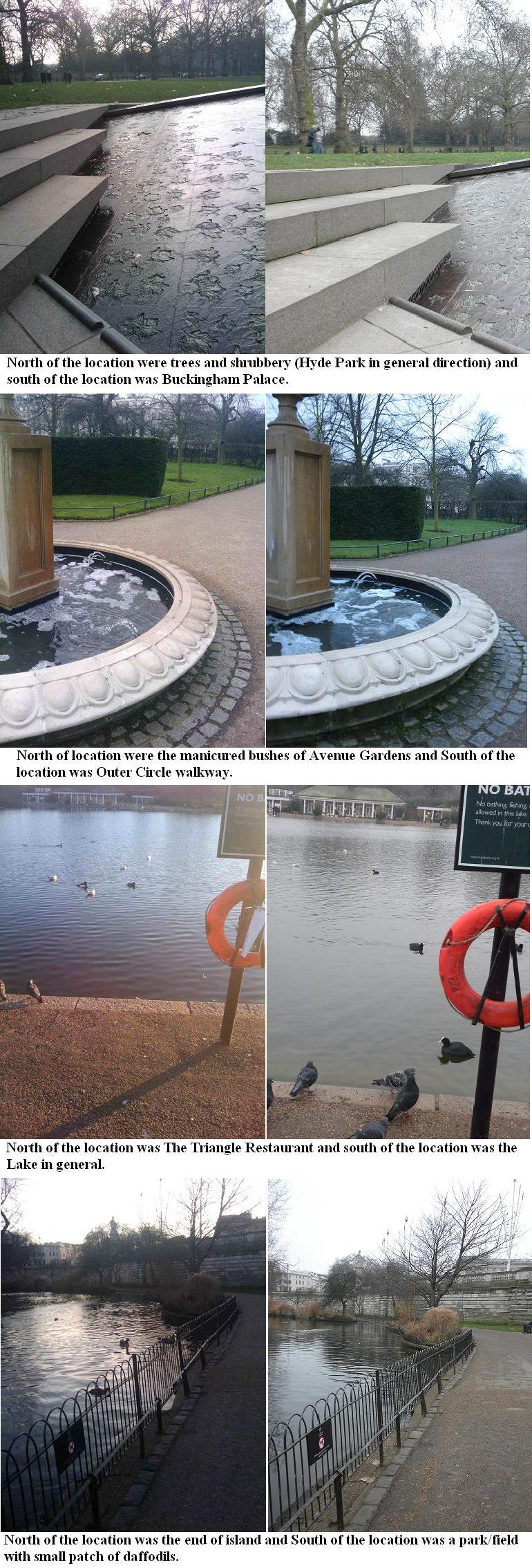
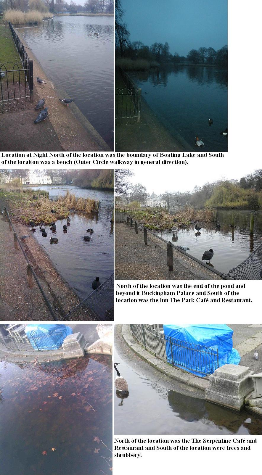
Left photos are the one that we were given. And the photos that are on the right side are out reproduction of each and single photo. Under every set of photos there is a nice description about what is around. This is the order of them: c, g, h, k, a, b, e, j, f, d, i.
In addition, below is a link that will take you to the premier showing of the Yellow Team's first production (in the form of a slide show) of Holy Pigeon P#$@ Batman, it's Penelope Poison!. Accompanying each picture is a caption including what is North and South of the water body.
Appendix A: Raw Data & Data Analysis
| Location: | Time | GPS Elevation | Air Temp | Water Temp | Wind Direction | Wind Speed | Latitude | Longitude |
|---|---|---|---|---|---|---|---|---|
| H | 11:35 | 59 ft | 8 °C | 7 °C | SE | 51.50813° | 000.12798° | |
| H | 49 ft | 7 °C | 7 °C | 51.50803° | 000.12762° | |||
| H | 55 ft | 10 °C | 7 °C | 51.50821° | 000.12753° | |||
| H | 11:35 | 54.3 ft | 8.3 °C | 7.0 °C | TEXT | |||
| D | 12:06 | 31 ft | 11 °C | 5 °C | S | 51.50359° | 000.13118° | |
| D | 36 ft | 10 °C | 5 °C | 51.50357° | 000.13223° | |||
| D | 49 ft | 5 °C | 5 °C | 51.50371° | 000.13227° | |||
| D | ||||||||
| J | 12:25 | 36 ft | 7 °C | 5 °C | S | 51.50191° | 000.13934° | |
| J | 39 ft | 6 °C | 5 °C | 51.50209° | 000.13946° | |||
| J | 30 ft | 6 °C | 5 °C | 51.50178° | 000.13988° | |||
| J | ||||||||
| A | 12:42 | 36 ft | 7 °C | 6 °C | SW | 51.50290° | 000.14225° | |
| A | 31 ft | 7 °C | 6 °C | 51.50292° | 000.14247° | |||
| A | 30 ft | 7 °C | 6 °C | 51.50288° | 000.14288° | |||
| A | ||||||||
| I | 13:25 | 42 ft | 6 °C | 5 °C | SW | 51.50446° | 000.16004° | |
| I | 50 ft | 6 °C | 5 °C | 51.50443° | 000.16006° | |||
| I | 45 ft | 6 °C | 5 °C | 51.50443° | 000.16007° | |||
| I | ||||||||
| E | 13:45 | 65 ft | 7 °C | 5 °C | SW | 51.50598° | 000.16958° | |
| E | 52 ft | 5 °C | 6 °C | 51.50597° | 000.16958° | |||
| E | 55 ft | 6 °C | 5 °C | 51.50597° | 000.16956° | |||
| E | ||||||||
| G | 13:55 | 72 ft | 5 °C | 6 °C | SW | 51.50727° | 000.17469° | |
| G | 70 ft | 5 °C | 5 °C | 51.50732° | 000.17467° | |||
| G | 70 ft | 6 °C | 6 °C | 51.50729° | 000.17469° | |||
| G | ||||||||
| K | 14:16 | 83 ft | 5 °C | 5 °C | SW | 51.51070° | 000.17588° | |
| K | 79 ft | 5 °C | 5 °C | 51.51070° | 000.17589° | |||
| K | 79 ft | 5 °C | 5 °C | 51.51067° | 000.17586° | |||
| K | ||||||||
| C | 14:35 | 95 ft | 5 °C | 5 °C | SW | 51.50637° | 000.18191° | |
| C | 87 ft | 5 °C | 5 °C | 51.50636° | 000.18189° | |||
| C | 90 ft | 6 °C | 5 °C | 51.50636° | 000.18188° | |||
| C | ||||||||
| B | 17:00 | 98 ft | 7 °C | 5 °C | SW | 51.52550° | 000.14784° | |
| B | 99 ft | 7 °C | 5 °C | 51.52537° | 000.14751° | |||
| B | 98 ft | 7 °C | 5 °C | 51.52538° | 000.14751° | |||
| B | ||||||||
| F | 17:25 | 91 ft | 6 °C | 5 °C | SW | 51.52781° | 000.16091° | |
| F | 110 ft | 6 °C | 5 °C | 51.52780° | 000.16091° | |||
| F | 98 ft | 6 °C | 5 °C | 51.52779° | 000.16092° | |||
| F | ||||||||
Appendix B: Visualization
Appendix C: Who Did What
Eva Marengo My contribution to the lab was taking the water and air temperature readings and helping record the data. At each location I took three readings of the water and of the air. In the lab report I did the associated write up. I also assisted at navigation and finding the perspective of the photos taken in order to replicate them.
Vivian Bateyunga My contribution to the lab was collecting data on wind direction using a basic compass and a Tesco plastic bag. I also described what was North and South of the location of the water body. I assisted with copy-editing the lab write up and figuring out the averages for the raw data collected.
Sandra Mamus Ngeseyan I was the principle data-recorder for the group and also helped determine what the wind-speed at each location was. It was extremely important that my handwriting was neat and the recording of data was done in an organized fashion. I helped to write up the description of the lab, as well as gather information from different members of the group.
Ivan Babic I helped with geocoding and determining where are the places exactly and how to get there. I was collecting data of Latitude, Longitude and Elevation. Wiki editing and visualization of data.


