Difference between revisions of "HIP:differential-gps"
Jump to navigation
Jump to search
(New page: From poweroff: Open SD card slot and make sure that blank card is inserted. Connect survey antenna to antenna port, directly below the SD slot Power on Close out the time dialogue Hit the ...) |
|||
| (4 intermediate revisions by 2 users not shown) | |||
| Line 1: | Line 1: | ||
| + | '''Operation instructions'''<br> | ||
From poweroff: | From poweroff: | ||
| − | Open SD card slot and make sure that blank card is inserted. | + | * Open SD card slot and make sure that blank card is inserted.(only if you are logging raw data) |
| − | Connect survey antenna to antenna port, directly below the SD slot | + | * Connect survey antenna to antenna port, directly below the SD slot |
| − | Power on | + | * Power on |
| − | Close out the time dialogue | + | * Close out the time dialogue |
| − | + | * Tap the DGPS configuration button and make sure that the GPS is in SBAS mode | |
| − | + | * Tap the GPS status icon on the desktop. | |
| − | Position the antenna so the mounting post is perpendicular to the ground and wait for the "fix not available" message to change to DGPS. Position should now ready your position, accurate to at least 2 meters. | + | * Position the antenna so the mounting post is perpendicular to the ground and wait for the "fix not available" message to change to DGPS. Position should now ready your position, accurate to at least 2 meters. |
| − | In order to perform more complex operations the GPS is equipped with the arcpad software. To access this software minimize the GPS status window by | + | * In order to perform more complex operations the GPS is equipped with the arcpad software. To access this software minimize the GPS status window by tapping on its tab in the status bar. |
| − | Next | + | * Next tap on the Arcpad 7.0.1 icon on the desktop. |
| − | Select the world map. | + | * Select the world map. |
| − | To start mapping | + | * To start mapping tap on the icon of the satellite with the cross-hairs to the lower right of it. |
| − | + | * Tap yes in the resulting dialogue box | |
| − | Ignore the error about the GPS data being too fast for arcpad, it is a known issue | + | * Ignore the error about the GPS data being too fast for arcpad, it is a known issue |
| − | Now | + | * Now tap on the arrow next to the previously mentioned icon. Tap GPS Tracklog. |
| − | Arcpad is now capturing data. | + | * Arcpad is now capturing data. |
| − | To capture GPS raw data for post processing | + | * To capture GPS raw data for post processing tap on the arrow next to the wrench and hammer and choose "Start logging GPS raw data". Data will be saved to the SD card. |
| + | ==Differential GPS Case== | ||
| + | [[Image:dGPS_box.jpg]]<br> | ||
| + | [[Image:dGPS_inventory.jpg]]<br> | ||
| + | (1) Main Antenna | ||
| + | (2) Differential GPS | ||
| + | (3) GPS Sleeve | ||
| + | (4) Antenna to GPS Cable | ||
| + | (5) Tripod | ||
| + | (6) Spare Battery<br> | ||
| + | (7) SD Memory Card | ||
| + | (8) Key of this Case | ||
| + | (9) Battery Charger | ||
| + | (10) AC Power Plugs | ||
| + | (11) Spare Antenna | ||
Latest revision as of 13:51, 26 May 2010
Operation instructions
From poweroff:
- Open SD card slot and make sure that blank card is inserted.(only if you are logging raw data)
- Connect survey antenna to antenna port, directly below the SD slot
- Power on
- Close out the time dialogue
- Tap the DGPS configuration button and make sure that the GPS is in SBAS mode
- Tap the GPS status icon on the desktop.
- Position the antenna so the mounting post is perpendicular to the ground and wait for the "fix not available" message to change to DGPS. Position should now ready your position, accurate to at least 2 meters.
- In order to perform more complex operations the GPS is equipped with the arcpad software. To access this software minimize the GPS status window by tapping on its tab in the status bar.
- Next tap on the Arcpad 7.0.1 icon on the desktop.
- Select the world map.
- To start mapping tap on the icon of the satellite with the cross-hairs to the lower right of it.
- Tap yes in the resulting dialogue box
- Ignore the error about the GPS data being too fast for arcpad, it is a known issue
- Now tap on the arrow next to the previously mentioned icon. Tap GPS Tracklog.
- Arcpad is now capturing data.
- To capture GPS raw data for post processing tap on the arrow next to the wrench and hammer and choose "Start logging GPS raw data". Data will be saved to the SD card.
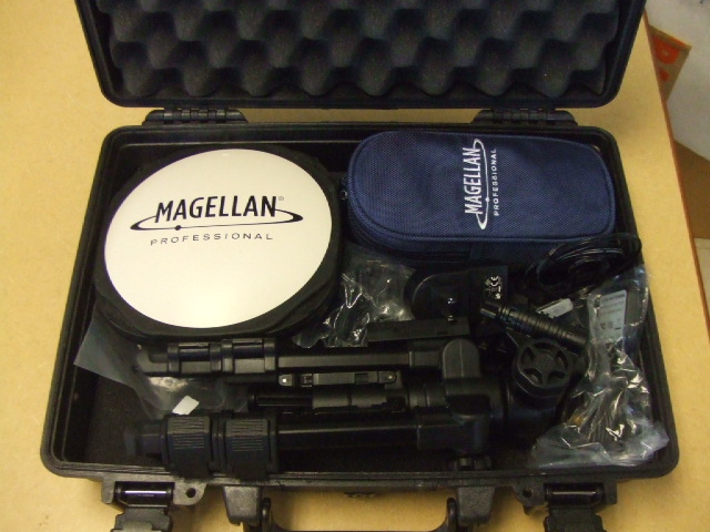
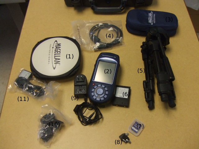
Differential GPS Case


(1) Main Antenna
(2) Differential GPS
(3) GPS Sleeve
(4) Antenna to GPS Cable
(5) Tripod
(6) Spare Battery
(7) SD Memory Card
(8) Key of this Case
(9) Battery Charger
(10) AC Power Plugs
(11) Spare Antenna