England-2011-lab1-yellow
Jump to navigation
Jump to search
Lab Write-up for Group Yellow
Lab PDF
Group Report 1: Where am I?
Yellow team: Ivan, Mamus, and Vivian.
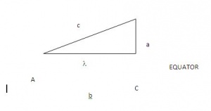
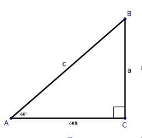
Our focus point was the distal end of Croom’s Hill Groove. We used three different methods/approach to identify our destination which includes Google earth, GPS and method of estimated (natural way). We used the GPS, Google earth, proximate measures, timer, camera and a compass as our tools. Below is a description of our identification by the use of longitude, latitude, elevation and distance.
Latitude: GPS reading: 51.47728 Google earth: 51.477543 Estimation:

The Wikipede edits Myriapoda.

The Wikipede edits Myriapoda.

The Wikipede edits Myriapoda.

The Wikipede edits Myriapoda.